Sacred City of Anuradhapura - 1 (Anuradhapura, Sri Lanka)
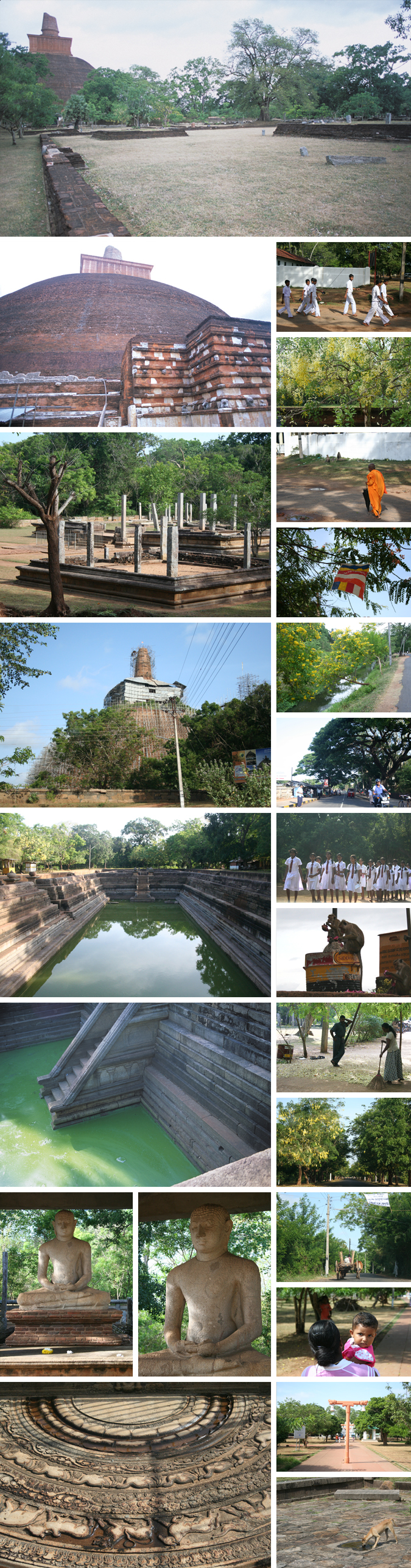
After the Buddhism arose, there was no budha image, and various one to hint Buddha was objects of the belief for hundreds of years. Those are called Chaitiya and it includes Bodhi tree, foot print or stupa where the Buddha bone is worshiped, In India where the Buddhism arose, if you circulate 'Bodhi Tree in Buddha Gaya' and 'Stupas in Sanchi' designated as World Heritage, it will be a grand tour. While, there is place where you can see both in one day and those are also designated as World Heritage. It is here Anurhadapura. Anuradhapura has 2300 years history since the Budhism transimitted. Unlike India where the Budhism declined, a lot of Sri Lankan people visit Anurhadapura in 21 century for worship though there was a rise and fall by the foreign enemy's invasion. Here is not a cultural heritage that became a fossil but the sacred ground that is still alive. The stupas in Anurhadapura have older fashioned style and are bigger than originator India.
The history of Anurardapra goes back until the tenth century at B.C. on archeology. It became the capital of the Sinhara dynasty in 380 B.C., and a grand city was built. The capital continued until the tenth century, and had been one of ten largest cities in the world. However, since the Tamel invasion from India is repeated, the capital moved to Polonnaruwa in 1017 A.C. and was abandoned for 800 years.
>It is difficult to read on the map the geographical principle of the city ruling a vast whole area. But, if eight places as 'Sri Maha Bodhi' and 'Ruwanweli Seya Dagob' in the central area are connected by line, the outline seems to become the appearance of the lion that turned it behind the head. Those are the points that were consecrated when the flower is scattered to show the sacred places by Mahinda who brought the Buddhism to Sri Lanka in 247 B.C.. Afterwards, it became the precincts of the head temple Maha Vihara built by the king. For long time, Anurhadapura prospered as the heartland of the Buddhism that the more people visited from all over the world.
Present Anurardapra is divided into the urban area and the ruin district in the west. The ruin district covered with green has the size of 2km from south to north and 5 km from east to west, placing the local villages here and there. The size is too wide to walk and so exhausted to circulate by bicycle although it is not understood in the car. The extent oneself may be a memory of a grand ancient city ? The size of the power that the Buddhism obtained here is not showed in it? Only making the power of the Buddhism visible might have been a principle by that the city was structured.
Transportation
4 hours and half by train and 5 hours by car from
Colombo. 3 km to Isurumuniya Vihara from the train station
Link
Accommodations
References
地球の歩き方「スリランカ」(ダイヤモンド・ビッグ社、2007
Lonely Planet Guide 'Sri Lanka' (Lonely Planet Publication,
2006)
世界美術全集11 インド・東南アジア(平凡社、1953)
インド古寺案内(神谷武夫、小学館、2005)
Mahavihara at Anuradhapura (T. G. Kulatunga, Tharanjee Prints,
2002)
Wikipedia
Upload
2007.11 Photos in English version, and photos and text in Japanese version
Update
2018.01 Change of photos and English text
Copyright (C) 2010 Future-scape Architects. All Rights Reserved.
無断転載は、ご遠慮いただくようにお願いいたします。